Background / justification
In Hawaiʻi, restoring native habitats is fundamental for conserving the endemic species and maintaining the ecological integrity of the region. The proposed projects aim to address key aspects of habitat restoration and conservation, focusing on the impact of restoration efforts on avian communities, the role of birds in seed dispersal and forest regeneration, and the effectiveness of translocating frugivores to restore ecological functions.
By evaluating the outcomes of restoration projects on bird populations, the first project will provide insights into the effectiveness of different restoration areas and their implications for biodiversity conservation. The second project looks to understand the mechanisms of seed dispersal by birds and the factors influencing forest recovery that will inform the development of targeted restoration approaches that enhance ecosystem resilience and biodiversity. The third project looks at assessing the dispersal patterns and habitat utilization of translocated frugivores, contributing to our understanding of their role in ecosystem restoration and the re-establishment of essential ecological functions.
Collectively, these projects will assist in advancing our knowledge of ecological restoration and avian conservation in Hawaiʻi. They will provide valuable data to guide management decisions, optimize restoration efforts, and contribute to the long-term preservation of the islands' unique biodiversity and natural heritage.
Objective 1: Impact of Restoration Projects on Avian Communities
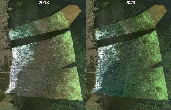
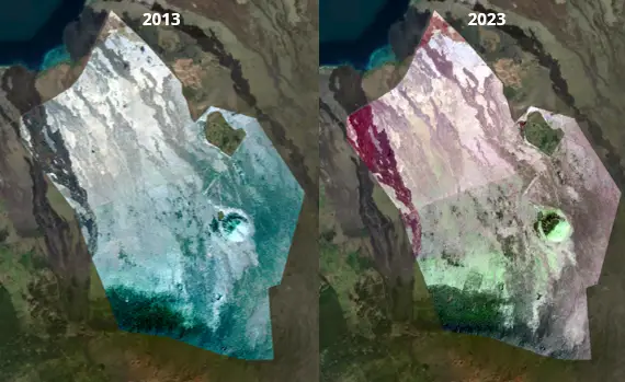
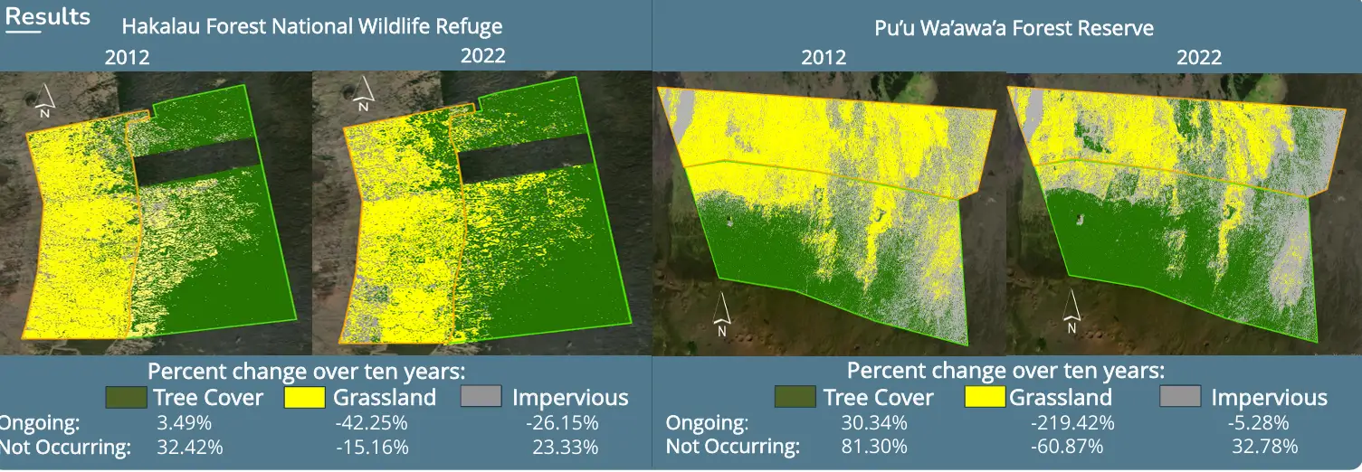
Small-scale restoration efforts can support native birds, but the response of bird populations to restoration varies depending on several factors, including forest maturity, species' geographic range, and external threats like disease. This project will analyze the impact of restoration projects on avian populations in selected sites on Hawaiʻi Island, considering species-specific responses and canopy cover change. We employ remote sensing and supervised classification to evaluate changes in vegetation structure at each restoration site. The two sites being analyzed are Hakalau Forest National Wildlife Refuge and Puʻuwaʻawaʻa Forest Reserve (FR) on Hawai’i Island (Figure 1). Each site has undergone years of differing restoration efforts, resulting in diverse changes within the canopy structure and grass cover. After classification and quantification of the vegetation changes in these areas that has occurred, statistical analyses from past forest bird surveys will then be run to determine the differences in avian communities within these areas over the past ten years. By understanding the specific needs and responses of different bird species to restoration efforts, this objective aims to provide insights that can guide more efficient and effective conservation strategies, ensuring the long-term survival of endemic birds and the overall health of the ecosystem.
Approach
Area Classification and Remote Sensing Analysis
- High-resolution satellite imagery for Hakalau NWR and Puʻuwaʻawaʻa Forest Reserve from 2012-2022 will be acquired.
- The imagery will be corrected for atmospheric conditions, sensor errors, and other distortions, normalizing brightness and contrast across all images.
- Indices like the Normalized Difference Vegetation Index (NDVI) will be utilized to assess vegetation density and type.
- Supervised classification techniques will be trained to differentiate between canopy cover, grass cover, rock or dirt surfaces, and water. We will also attempt to differentiate between ‘ohi’a (Metrosideros polymorpha) and koa (Acaica koa) cover.
- Changes in area and density of each category will be calculated to assess vegetation change each year.
- The supervised classification will be tested and calibrated for accuracy.
- Change detection algorithms will be employed to identify significant alterations in vegetation over time.
- Significant and non-significant changes will be reported and maps created to display landscape alterations.
Point Count Analysis
- Data from the Hawaiʻi Forest Bird Interagency Database Project will be utilized from each of the transects that exist within the restoration areas. This data follows point-transect sampling procedures to record detection type and distance to detected birds.
- Distance sampling methods will be used to correct for undetected individuals and estimate bird densities.
- Analysis on the relative abundance of selected bird species in restoration areas over a 10-year period within the areas displaying change in canopy cover and vegetation will occur.
- Trends in the bird populations in areas with and without forest restoration will be compared.
- Statistics packages to model bird densities at each station within each site and assess trends over time will be utilized.
Objective 2: Informing Management Decisions for Avian Habitat Restoration Utilizing Seed Dispersal
Restoration ecologists face challenges in re-establishing native populations and ecosystem processes in degraded environments. Effective and cost-efficient methods for habitat restoration in Hawaiʻi are still being explored, with varying results across different sites. Seed dispersal by birds can be helpful for forest recovery, especially in areas adjacent to intact forests or forest fragments. This project seeks to identify key information that can inform management decisions aimed at restoring avian habitat adjacent to intact forests or forest fragments. We will investigate the role of birds in seed dispersal and the factors that influence the recovery of tropical forests, particularly in former agricultural lands. Analyzing the use of bird perching structures and adopting the nucleation model of succession will be examined for their potential to enhance seed dispersal and forest recovery. By setting up transects of seed rain traps outside of intact forest, we will provide comprehensive data on the furthest extent of bird-mediated seed dispersal and its impact on habitat restoration. This study aims to examine seed rain travel and the effects of perches on dispersal patterns, contributing to effective management decisions that can be tailored to the specific ecological and environmental conditions of the Hawaiian Islands.
Approach
Seed Dispersal Distance, Measurements, and Distribution
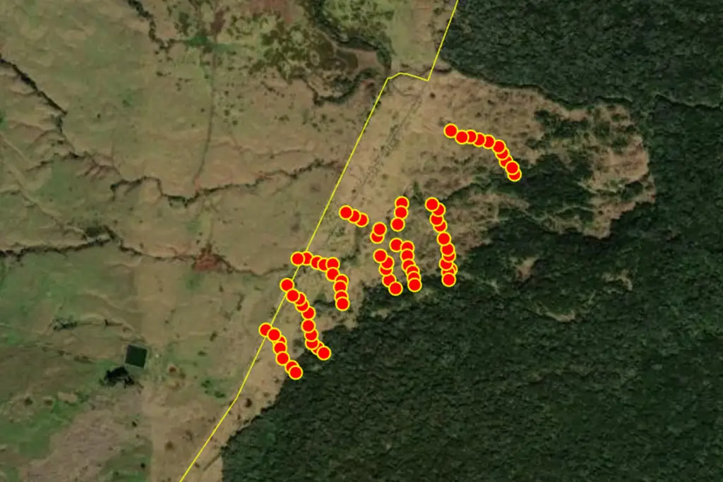
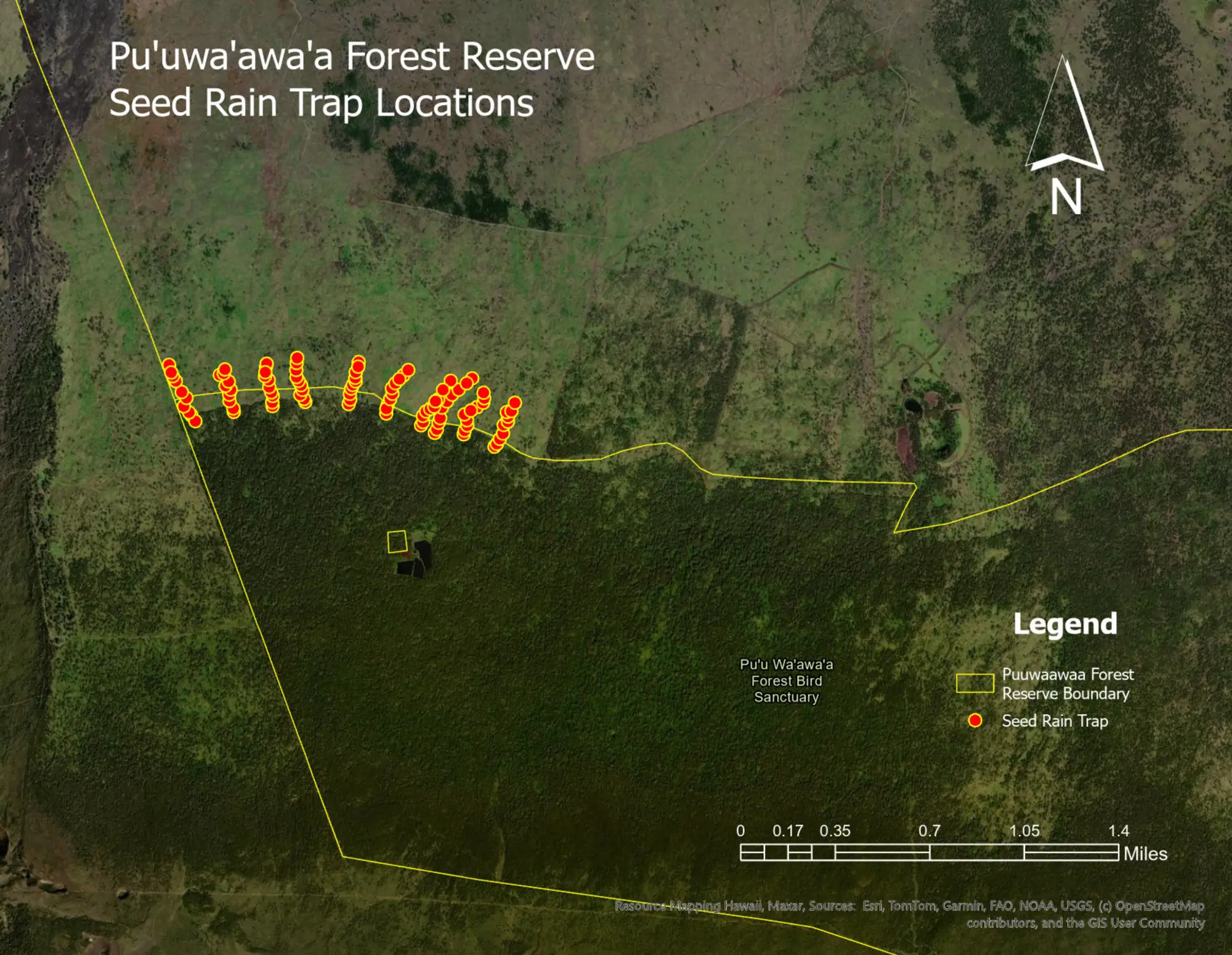
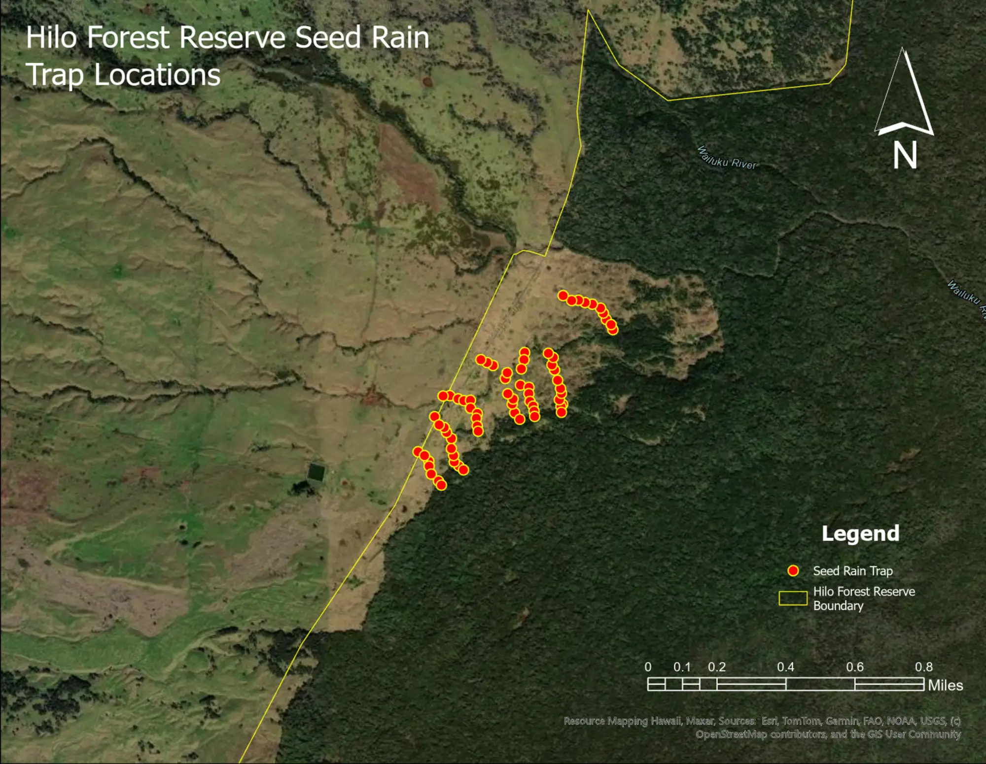
- We will measure seed rain in Hilo Forest Reserve and Puʻuwaʻawaʻa Forest Reserve by placing hoop style traps along transects within these areas. These transects begin within the intact forest and extend into the open matrix (pasture/grassland). Traps are at least 20 m apart from one another and will be placed under remnant trees within the open matrix or under perches (in the absence of remnant trees). There are 10 transects per site, and each transect extends at least 200 m into the open matrix (Figure 2).
- Trap contents will be collected twice a month, sorted, and seeds will be identified and recorded.
Fruit Abundance
- All fruiting plant species within a 20-m radius of each trap will be recorded during each seed rain collection visit. All fruiting plant species along the forest edge will also be recorded during this time. This will help inform which seeds we would expect to find in the traps.
- Measures of fruiting activity for each species surveyed will be calculated, including percent occurrence and indexed abundance.
- Patterns in seed rain and fruit phenology will be compared using daily seed rain averages.
Objective 3: Dispersal and Habitat Utilization by Translocated Frugivores
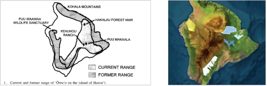
The abundance of mobile organisms like birds is closely related to resource availability, and their movements are essential for services like seed dispersal and pollination. Translocation of native frugivores, such as the ʻalalā (Corvus hawaiiensis) and ʻōmaʻo (Myadestes obscurus), has been proposed as a management tool to restore seed dispersal functions in areas where native frugivores are extinct. The success of bird translocations depends on factors such as survival rates, dispersal behavior, and long-term population persistence. This project focuses on understanding how a translocated frugivore population, specifically the ʻōmaʻo, disperses and utilizes restored habitats. We aim to explore the relationship between resource availability and bird abundance and assess the role of these translocated frugivores in restoring seed dispersal functions in forests where native frugivores no longer exist. By examining the survival rates, dispersal behavior, and habitat utilization of translocated ʻōmaʻo, we seek to evaluate the effectiveness of reintroduction as a conservation strategy. The research will contribute to understanding the ecological impacts of translocated frugivores on plant community composition and seed dispersal services, providing valuable insights for future conservation efforts aimed at restoring and preserving Hawaiʻi's unique avian biodiversity and ecosystems.
Approach
- Beginning September 2025, we will translocate 30-60 ʻōmaʻo individuals from stable populations in Windward Hawai’i to the Leeward Puʻuwaʻawaʻa Forest Bird Sanctuary (Figure 3).
- Birds will be captured using standard mist-netting procedures and processed for banding and VHF radio transmitter fitting.
- Captured individuals will be transported and released at Puʻuwaʻawaʻa Forest Reserve. We will track their dispersal and movements, habitat preferences, and interactions using VHF telemetry.
- Movement patterns, home range size, and behaviors will be analyzed to understand their adaptation to the new environment. Home range maps will be created and diet composition will be determined from the field observations.
- After the transmitters are dropped or run out of battery life, annual surveys to estimate the population of released birds will be conducted and new birds will be introduced accordingly.
Partners / collaborators
- Hawaiʻi Division of Forestry and Wildlife- Alex Wang and supporting staff
- Research Corportation of the University of Hawaii- Cara Thow and supporting staff
- United States Geological Survey- Rick Camp
- Department of Hawaiian Home Lands- Kualiʻi Camara